Tectonic Plates
Scientists have successfully used it to explain many geological events, such as earthquakes and volcanic eruptions as well as mountain building and the formation of the oceans and continents.
Plate tectonics arose from an earlier theory proposed by German scientist Alfred Wegener in 1912. Looking at the shapes of the continents, Wegener found that they fit together like a jigsaw puzzle. Using this observation, along with geological evidence he found on different continents, he developed the theory of continental drift, which states that today’s continents were once joined together into one large landmass.
Geologists of the 1950s and 1960s found evidence supporting the idea of tectonic plates and their movement. They applied Wegener’s theory to various aspects of the changing earth and used this evidence to confirm continental drift. By 1968 scientists integrated most geologic activities into a theory called the New Global Tectonics, or more commonly, Plate Tectonics.
Tectonic Plates

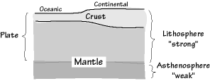
Tectonic plates are made of either oceanic or continental crust or the very top part of the mantle, a layer of rock inside the earth. This crust and upper mantle form what is called the lithosphere. Under the lithosphere lies a fluid rock layer called the asthenosphere. The rocks in the asthenosphere move in a fluid manner because of the high temperatures and pressures found there. Tectonic plates are able to float upon the fluid asthenosphere because they are made of rigid lithosphere.
Continental Crust
The earth’s solid surface is about 40 percent continental crust. Continental crust is much older, thicker and less dense than oceanic crust. The thinnest continental crust, between plates that are moving apart, is about 15 km thick. In other places, such as mountain ranges, the crust may be as much as 75 km thick. Near the surface, it is composed of rocks that are felsic (made up of minerals including feldspar and silica). Deeper in the continental crust, the composition is mafic (made of magnesium, iron, and other minerals).
Oceanic Crust
Oceanic crust makes up the other 60 percent of the earth’s solid surface. Oceanic crust is, in general, thin and dense. It is constantly being produced at the bottom of the oceans in places called mid-ocean ridges—undersea volcanic mountain chains formed at plate boundaries where there is a build-up of ocean crust. This production of crust does not increase the physical size of the earth, so the material produced at mid-ocean ridges must be recycled, or consumed, somewhere else. Geologists believe it is recycled back into the earth in areas called subduction zones, where one plate sinks underneath another and the crust of the sinking plate melts back down into the earth. Oceanic crust is continually recycled so that its age is generally not greater than 200 million years. Oceanic crust averages between 5 and 10 km thick. It is composed of a top layer of sediment, a middle layer of rock called basalt, and a bottom layer of rock called gabbro. Both basalt and gabbro are dark-colour igneous, or volcanic, rocks.
Plate Sizes

Currently, there are seven large and several small plates. The largest plates include the Pacific plate, the North American plate, the Eurasian plate, the Antarctic plate, and the African plate. Smaller plates include the Cocos plate, the Nazca plate, the Caribbean plate, and the Gorda plate. Plate sizes vary a great deal. The Cocos plate is 2000 km wide, while the Pacific plate is the largest plate at nearly 14,000 km wide.
Plate Movement
Geologists study how tectonic plates move relative to a fixed spot in the earth’s mantle and how they move relative to each other. The first type of motion is called absolute motion, and it can lead to strings of volcanoes. The second kind of motion, called relative motion, leads to different types of boundaries between plates: plates moving apart from one another form a divergent boundary, plates moving toward one another form a convergent boundary, and plates that slide along one another form a transform plate boundary. In rare instances, three plates may meet in one place, forming a triple junction. Current plate movement is making the Pacific Ocean smaller, the Atlantic Ocean larger, and the Himalayan mountains taller.
Measuring Plate Movement
Geologists discovered absolute plate motion when they found chains of extinct submarine volcanoes. A chain of dead volcanoes forms as a plate moves over a plume, a source of magma, or molten rock, deep within the mantle. These plumes stay in one spot, and each one creates a hot spot in the plate above the plume. These hot spots can form into a volcano on the surface of the earth. An active volcano indicates a hot spot as well as the youngest region of a volcanic chain. As the plate moves, a new volcano forms in the plate over the place where the hot spot occurs. The volcanoes in the chain get progressively older and become extinct as they move away from the hot. Scientists use hot spots to measure the speed of tectonic plates relative to a fixed point. To do this, they determine the age of extinct volcanoes and their distance from a hot spot. They then use these numbers to calculate how far the plate has moved in the time since each volcano formed. Today, the plates move at velocities up to 18.5 cm per year. On average, they move nearly 4 to 7 cm per year.
Divergent Plate Boundaries

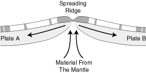
Divergent plate boundaries occur where two plates are moving apart from each other. When plates break apart, the lithosphere thins and ruptures to form a divergent plate boundary. In the oceanic crust, this process is called seafloor spreading, because the splitting plates are spreading apart from each other. On land, divergent plate boundaries create rift valleys—deep valley depressions formed as the land slowly splits apart.
When seafloor spreading occurs, magma, or molten rock material, rises to the sea floor surface along the rupture. As the magma cools, it forms new oceanic crust and lithosphere. The new lithosphere is less dense, so it rises, or floats, higher above older lithosphere, producing long submarine mountain chains known as mid-ocean ridges. The Mid-Atlantic Ridge is an underwater mountain range created at a divergent plate boundary in the middle of the Atlantic Ocean. It is part of a worldwide system of ridges made by seafloor spreading. The Mid-Atlantic Ridge is currently spreading at a rate of 2.5 cm per year . The mid-ocean ridges today are 60,000 km long, forming the largest continuous mountain chain on earth. Earthquakes, faults, underwater volcanic eruptions, and vents, or openings, along the mountain crests produce rugged seafloor features, or topography.
Divergent boundaries on land cause rifting, in which broad areas of land are uplifted, or moved upward. These uplifts and faulting along the rift result in rift valleys. Examples of rift valleys are found at the Krafla Volcano rift area in Iceland as well as at the East African Rift Zone—part of the Great Rift Valley that extends from Syria to Mozambique and out to the Red Sea. In these areas, volcanic eruptions and shallow earthquakes are common.
Convergent Plate Boundaries

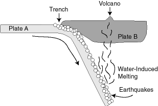
Convergent plate boundaries occur where plates are consumed, or recycled back into the earth’s mantle. There are three types of convergent plate boundaries: between two oceanic plates, between an oceanic plate and a continental plate, and between two continental plates. Subduction zones are convergent regions where oceanic crust is thrust below either oceanic crust or continental crust. Many earthquakes occur at subduction zones, and volcanic ridges and oceanic trenches form in these areas.
In the ocean, convergent plate boundaries occur where an oceanic plate descends beneath another oceanic plate. Chains of active volcanoes develop 100 to 150 km above the descending slab as magma rises from under the plate. Also, where the crust slides down into the earth, a trench forms. Together, the volcanoes and trench form an intra-oceanic island arc and trench system. A good example of such a system is the Mariana Trench system in the western Pacific Ocean, where the Pacific plate is descending under the Philippine plate. In these areas, earthquakes are frequent but not large. Stress in and behind the arc often causes the arc and trench system to move toward the incoming plate, which opens small ocean basins behind the arc. This process is called back-arc seafloor spreading.
Convergent boundaries that occur between the ocean and land create continental margin arc and trench systems near the margins, or edges, of continents. Volcanoes also form here. Stress can develop in these areas and cause the rock layers to fold, leading to earthquake faults, or breaks in the earth’s crust called thrust faults. The folding and thrust faulting thicken the continental crust, producing high mountains. Many of the world’s large destructive earthquakes and major mountain chains, such as the Andes Mountains of western South America, occur along these convergent plate boundaries.
When two continental plates converge, the incoming plate drives against and under the opposing continent. This often affects hundreds of miles of each continent and, at times, doubles the normal thickness of continental crust. Colliding continents cause earthquakes and form mountains and plateaus. The collision of India with Asia has produced the Himalayan Mountains and Tibetan Plateau.
Transform Plate Boundaries

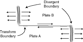
A transform plate boundary, also known as a transform fault system, forms as plates slide past one another in opposite directions without converging or diverging. Early in the plate tectonic revolution, geologists proposed that transform faults were a new class of fault because they “transformed” plate motions from one plate boundary to another. Canadian geophysicist J. Tuzo Wilson studied the direction of faulting along fracture zones that divide the mid-ocean ridge system and confirmed that transform plate boundaries were different than convergent and divergent boundaries. Within the ocean, transform faults are usually simple, straight fault lines that form at a right angle to ocean ridge spreading centres. As plates slide past each other, the transform faults can divide the centres of ocean ridge spreading. By cutting across the ridges of the undersea mountain chains, they create steep cliff slopes. Transform fault systems can also connect spreading centres to subduction zones or other transform fault systems within the continental crust. As a transform plate boundary cuts perpendicularly across the edges of the continental crust near the borders of the continental and oceanic crust, the result is a system such as the San Andreas transform fault system in California.
Triple Junctions
Rarely, a group of three plates, or a combination of plates, faults, and trenches, meet at a point called a triple junction. The East African Rift Zone is a good example of a triple plate junction. The African plate is splitting into two plates and moving away from the Arabian plate as the Red Sea meets the Gulf of Aden. Another example is the Mendocino Triple Junction, which occurs at the intersection of two transform faults (the San Andreas and Mendocino faults) and the plate boundary between the Pacific and Gorda plates.
Current Plate Movement
Plate movement is changing the sizes of our oceans and the shapes of our continents. The Pacific plate moves at an absolute motion rate of 9 cm per year away from the East Pacific Rise spreading centre, the undersea volcanic region in the eastern Pacific Ocean that runs parallel to the western coast of South America. On the other side of the Pacific Ocean, near Japan, the Pacific plate is being subducted, or consumed under, the oceanic arc systems found there. The Pacific Ocean is getting smaller as the North and South American plates move west. The Atlantic Ocean is getting larger as plate movement causes North and South America to move away from Europe and Africa. Since the Eurasian and Antarctic plates are nearly stationary, the Indian Ocean at present is not significantly expanding or shrinking. The plate that includes Australia is just beginning to collide with the plate that forms Southeast Asia, while India’s plate is still colliding with Asia. India moves north at 5 cm per year as it crashes into Asia, while Australia moves slightly farther away from Antarctica each year.
Causes of Plate Motion
Although plate tectonics has explained most of the surface features of the earth, the driving force of plate tectonics is still unclear. According to geologists, a model that explains plate movement should include three forces. Those three forces are the pull of gravity; convection currents, or the circulating movement of fluid rocky material in the mantle; and thermal plumes, or vertical columns of molten rocky material in the mantle.
Plate Movement Caused by Gravity
Geologists believe that tectonic plates move primarily as a result of their own weight, or the force of gravity acting on them. Since the plates are slightly denser than the underlying asthenosphere, they tend to sink. Their weight causes them to slide down gentle gradients, such as those formed by the higher ocean ridge crests, to the lower subduction zones. Once the plate’s leading edge has entered a subduction zone and penetrated the mantle, the weight of the slab itself will tend to pull the rest of the plate toward the trench. This sinking action is known as slab-pull because the sinking plate edge pulls the remainder of the plate behind it. Another kind of action, called ridge-push, is the opposite of slab-pull, in that gravity also causes plates to slide away from mid-ocean ridges. Scientists believe that plates pushing against one another also causes plate movement.
Convection Currents
In 1929 British geologist Arthur Holmes proposed the concept of convection currents—the movement of molten material circulating deep within the earth—and the concept was modified to explain plate movement. A convection current occurs when hot, molten, rocky material floats up within the asthenosphere, then cools as it approaches the surface. As it cools, the material becomes denser and begins to sink again, moving in a circular pattern. Geologists once thought that convection currents were the primary driving force of plate movement. They now believe that convection currents are not the primary cause, but are an effect of sinking plates that contributes to the overall movement of the plates.
Thermal Plumes
Some scientists have proposed the concept of thermal plumes, vertical columns of molten material, as an additional force of plate movement. Thermal plumes do not circulate like convection currents. Rather, they are columns of material that rise up through the asthenosphere and appear on the surface of the earth as hot spots. Scientists estimate thermal plumes to be between 100 and 250 km in diameter. They may originate within the asthenosphere or even deeper within the earth at the boundary between the mantle and the core.
Document Actions

 Like us on Facebook